Coquet flooding fears allayed despite concerns about raised bank holding back up to 200 Olympic sized swimming pools of water
and live on Freeview channel 276
A flood alert was issued for the River Coquet near Rothbury on Tuesday but this has now been downgraded by the Environment Agency and river levels are now stable.
An Environment Agency spokesman said: “While river levels were high due to recent snow melt, we issued a flood alert and closed the flood gates at Rothbury. This has now been downgraded, and the flood gates have been reopened.”
Advertisement
Hide AdAdvertisement
Hide AdConcerns were heightened after heavy rain and snowmelt earlier this month caused the River Coquet to overtop its banks and merge with Caistron Lakes, upstream of Rothbury.
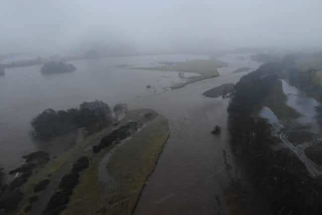

Around half of the river is now flowing from the main River Coquet into the lakes area, which is currently holding between 100,000 and 500,000 cubic metres of water (between 40 and 200 Olympic sized swimming pools of water).
The impounded water is currently being held in place by the lake’s raised aggregate bank, which has since experienced erosion due to the overflow of water from the lakes returning to the River Coquet. This bank is now at risk of failure.
Should the bank fail, it will release water from the lakes area downstream, and while this will not create a sudden impact, it does have the potential to raise river levels more quickly than normal. It may flood agricultural and low lying land, and some recreational areas.
Advertisement
Hide AdAdvertisement
Hide AdThe spokesman added: “Longer term, we are working with Natural England to monitor the impacts this has on the main River Coquet and its natural environment. The Coquet is a naturally wandering river and erosion, switching channels, or the formation of new channels is an entirely normal occurrence.
“Public safety remains our priority. The Environment Agency is working with partners including Northumberland County Council, Northumberland Fire and Rescue Service and Northumbria Police to reduce the risk to the local area.
"We have developed a robust incident response plan to minimise the impact on the community and environment. We’re monitoring river levels in the area and we will issue flood alerts if necessary.”
Northumberland County Council temporarily closed footpaths and the Cow Haugh car park at Rothbury riverside when the flood alert was issued.